Moza Fm
Type Locality and Naming
Pegu (Bago) Yoma-Sittaung Basin, [Original Publication: Barber, A. J., Khin Zaw & Crow, M. J. (eds) 2017. Myanmar: Geology, Resources and Tectonics. Geological Society, London, Memoirs, 48, 169-183]
[Figure: Map showing location of sub-basins of the Central Myanmar Basin (after Myint Thein and M. Maung 2017)]
Lithology and Thickness
Sandstone. A 1200 m thick and is an interbedded unit of sandstone and shale with frequent fossiliferous lenses of pelecypods, coral fragments and mud clasts. The presence of packages of thin sandstone beds with various types of ripple marks is conspicuous.
[Figure: (b) Moza Formation in a road-cut at mile post 310/5, east side of Yangon–Mandalay Expressway. (c) Laterally persistent shales and sandstone beds of the Moza Formation, road-cut at mile post 309/5 west side of Expressway. (d) Alternating uniform beds of sandstone (with flaser bedding) and shale in the Moza Formation, mile post 306/3 west side of Expressway (after Myint Thein and M. Maung 2017)]
[Figure: (a) Flaser bedding in the Moza Formation, mile post 306/3, west side of Yangon–Mandalay Expressway. (b) Cross-bedded fining-upwards sandstone with flaser bedding and shale, Moza Formation, mile post 304/7, west side of Expressway (after Myint Thein and M. Maung 2017)]
[Figure: (e, f) Convolute laminations, Moza Formation, mile post 251/7, east side of Expressway (after Myint Thein and M. Maung 2017)]
Relationships and Distribution
Lower contact
Conformable with Taungtalone Sandstone Fm
Upper contact
Conformable with Khabo Sandstone Fm
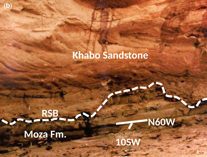
[Figure: (b)regressive sequence boundary (RSB) between the sand-bar facies of the Khabo Sandstone Fm (Upper Miocene) and mixed-flat (tidal-flat) facies of Moza Formation (Lower–Middle Miocene) (after Than et al., 2017)]
Regional extent
This Fm is developed in Pegu (Bago) Yoma-Sittaung Basin (BYSB)
[Figure: a) Composite stratigraphic correlation of Myanmar Central Basins (after Than et al., 2017)]
[Figure: b) Stratigraphic correlation of Bago (Pegu) Yoma-Sittaung Basin (after Than et al., 2017)]
GeoJSON
Fossils
Trace fossils of the Cruziana (Cruziana, Aulichnites, Planolites, Astericites) and Skolithos ichnofacies (Skolithos, Ophiomorpha, Diplocraterium) and rare ‘sand balls’ generated by sand crabs are observed.
[Figure: (a) Cruziana sp. at 306/2 mile post, east side of Yangon–Mandalay Expressway. (C) Skolithos sp. seen on the bedding plane at 262/7 mile post, west side of Expressway (after Myint Thein and M. Maung 2017)]
Age
Depositional setting
Middle shoreface to offshore environments
Additional Information
.jpg)
.jpg)
.jpg)
.jpg)

.jpg)